The Complete Guide to Interactive Lot Maps for Home Builders
Your Site Plan Shouldn't Be a PDF
Every home builder has a site plan. It's one of the first things created when a new community is planned — a visual map showing every lot, street, amenity, and common area in the neighborhood.
And for decades, the way builders shared that site plan with buyers was simple: print it out, hand it over at the sales office, or upload a PDF to the website.
That worked when buyers drove through neighborhoods on Saturday mornings to start their search. It doesn't work now.
Today, the majority of homebuyers begin their search online. They want to browse communities from their phone, see what's available, check pricing, and narrow down their options — all before they ever schedule a visit. A static PDF can't do any of that.
Interactive lot maps solve this problem. They turn your existing site plan into a clickable, filterable, real-time tool that lets buyers explore your community the way they actually want to — on their own terms, on any device.
This guide covers everything a builder marketing team needs to know about interactive lot maps: what they are, how they work, what to look for when choosing a tool, and why they've become essential for any builder selling homes online.
What Is an Interactive Lot Map?
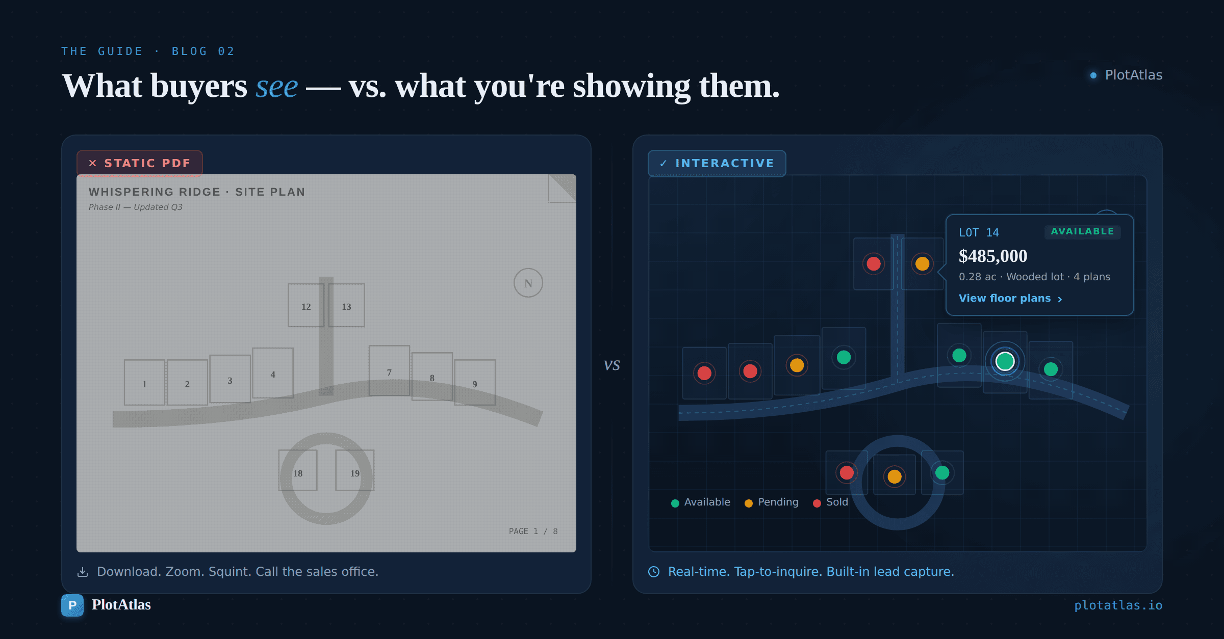
An interactive lot map is a digital version of your community site plan where each lot is clickable. Instead of a flat image, buyers see a visual map they can interact with — tapping or clicking individual lots to see details like:
Lot status — Available, Sold, Pending, or Under Contract
Pricing — Base price or price range for that homesite
Square footage — Lot size and/or home square footage
Available floor plans — Which plans can be built on that specific lot
Lot premiums — View lot, corner lot, cul-de-sac, etc.
Photos and renderings — Elevations or completed home images
Some interactive lot maps also include lead capture — letting buyers submit an inquiry or request more information directly from the map without navigating to a separate contact page.
Think of it as the difference between handing someone a paper menu and letting them browse a restaurant's full online ordering system. The information is the same, but the experience is fundamentally different.
Why Static Site Plans Fall Short
Before getting into what makes interactive lot maps valuable, it's worth understanding why the status quo — static PDFs and images — creates friction for both buyers and builders.
Buyers Can't Self-Serve
A static site plan shows lot boundaries and street layouts, but it doesn't tell buyers what's actually available right now. To find out if Lot 42 is still open, what it costs, or which floor plans fit on it, the buyer has to call or email the sales office.
Some buyers will make that call. Many won't. They'll move on to another builder whose community information is easier to access.
Information Goes Stale Immediately
The moment a lot sells, your static site plan is outdated. If your marketing team has to update a PDF, re-export it, and re-upload it to the website every time a status changes, you're always a step behind. And when a buyer shows up excited about a lot that sold three days ago, that's a trust problem.
No Lead Capture
A PDF doesn't know who's looking at it. It can't capture contact information, track which lots get the most attention, or alert your sales team when a buyer is interested. It's a one-way document — information goes out, but nothing comes back.
Mobile Experience Is Poor
PDFs are not mobile-friendly. Buyers on their phones have to pinch, zoom, and scroll around a document that was designed for print. The text is small, the lots are hard to tap, and the overall experience signals that the builder's digital presence is behind the times.
How Interactive Lot Maps Work
The technology behind interactive lot maps is simpler than most builders expect. Here's the typical workflow:
Step 1: Upload Your Site Plan
You start with the same site plan image you already have — the community map your land team or architect created. Most tools accept standard image formats (PNG, JPG) at high resolution.
Step 2: Define Lot Boundaries
Using the lot map tool's editor, you draw boundaries around each lot on the map. This is a one-time setup per community — you're essentially telling the software where each lot is located on the image.
Step 3: Add Lot Data
For each lot, you enter the relevant details: lot number, status, price, square footage, available floor plans, premiums, and any other information buyers should see. Many tools support CSV import for bulk updates, so you don't have to enter 150 lots one at a time.
Step 4: Embed on Your Website
The tool generates an embed code — a snippet of HTML you paste into your website. The interactive map appears directly on your community page, matching your site's layout. Most tools work with any website platform: WordPress, Squarespace, Wix, or custom-built sites.
Step 5: Update as Lots Sell
When a lot status changes, your sales team or marketing manager updates it in the tool's dashboard. The change reflects on the website immediately — no re-uploading files, no waiting for an agency to make edits.
Some platforms even support webhook integrations with your CRM, so lot status updates can flow automatically between systems.
What Buyers Actually Do With Interactive Lot Maps
Understanding buyer behavior on interactive lot maps helps explain why they convert better than static alternatives.
They Filter by What Matters to Them
Not every buyer wants the same thing. Some want a corner lot. Some want the largest homesite. Some are budget-focused and want to see the lowest-priced available lots first.
Interactive maps let buyers filter by status, price range, lot size, or floor plan availability — narrowing from 100+ lots to the handful that match their criteria in seconds.
They Explore Before They Engage
Most buyers aren't ready to talk to a salesperson the first time they look at a community. They want to browse quietly, compare options, and come back later when they've made a shortlist.
Interactive maps let them do exactly that. They can explore the entire community, save mental notes on preferred lots, and return when they're ready to take the next step. This self-serve experience mirrors how people shop for everything else online — and buyers expect it from builders too.
They Convert When the Moment Is Right
When a buyer finds a lot they like — the right size, the right price, the right location in the community — they want to act on it immediately. Interactive maps with built-in lead capture let buyers submit an inquiry right from the lot detail view.
No navigating to a separate contact page. No copying a lot number into an email. The path from "I'm interested" to "I've submitted my info" takes seconds.
They Come Back
Interactive maps give buyers a reason to return to your website. As lots sell and new inventory opens up, the map reflects those changes in real time. Buyers who didn't find what they wanted last week will check back — and every return visit is another opportunity to convert.
What to Look for When Choosing an Interactive Lot Map Tool
Not all interactive lot map solutions are the same. Here's what matters most when evaluating your options:
Ease of Setup
How quickly can you go from site plan image to live interactive map? The best tools make this possible in minutes, not weeks. If setup requires custom development or a lengthy onboarding process, it's going to delay your community launch.
Real-Time Updates
Your sales team needs to update lot statuses without waiting for a technical team. Look for a dashboard that's simple enough for any team member to use — not just someone with a CMS login or development background.
Mobile Experience
More than half of your buyers will view the lot map on a mobile device. The map needs to be fully responsive — not just "viewable on mobile" but genuinely easy to use with touch interactions, readable text, and fast load times.
Lead Capture
The map should capture buyer inquiries directly. When a buyer taps on a lot and wants more information, the lead should flow to your inbox or CRM automatically. If the map sends buyers to a generic contact form on another page, you're adding unnecessary friction.
CRM Integration
Leads from the lot map should sync with whatever CRM your sales team uses — HubSpot, Lasso, or another system. Webhook support or direct integrations prevent leads from falling through the cracks.
Embedding Flexibility
The map needs to work on your existing website without a redesign. A simple embed code that drops into any page — regardless of your CMS — is the standard. If the tool requires a specific website platform or custom development to integrate, that's a limitation.
Pricing Transparency
You should know exactly what the tool costs before you commit. Look for clear pricing tiers based on the number of communities, lots, or leads — not custom quotes that vary based on how the sales call goes.
Interactive Lot Maps vs. Other Digital Tools
Builders sometimes compare interactive lot maps to other digital tools they've seen or been pitched. Here's how they stack up:
Interactive Lot Maps vs. Virtual Tours
Virtual tours show buyers the interior of a home — finishes, layouts, room flow. They're a presentation tool. Interactive lot maps show buyers the community layout and what's available. They're a decision-making tool.
Both have value, but they solve different problems. A buyer might watch a virtual tour to get excited about a floor plan, but they use a lot map to decide where they want to live in the community and whether the price fits their budget.
For builders who have to choose where to invest first, interactive lot maps typically have a more direct impact on lead generation because they serve buyers who are further along in their decision — they've already decided they're interested in the community and now they're evaluating specific lots.
Interactive Lot Maps vs. Floor Plan Galleries
Floor plan galleries and interactive lot maps are complementary. The floor plan gallery shows buyers what they can build. The lot map shows them where they can build it — and links the two together.
The most effective builder websites connect lot maps to floor plans, so a buyer clicking on a specific lot can see exactly which floor plans are available for that homesite.
Interactive Lot Maps vs. MLS/Listing Feeds
MLS feeds pull listing data from real estate databases and display it on your website. This works for move-in-ready homes but doesn't cover lots that haven't been built on yet.
Interactive lot maps cover the full community — available lots, homes under construction, and completed inventory. They're the builder's tool, not the real estate agent's tool.
The ROI of Interactive Lot Maps
The business case for interactive lot maps comes down to three measurable outcomes:
More Qualified Leads
Buyers who interact with a lot map have already self-selected. They've browsed the community, found lots that match their criteria, and made a deliberate decision to request information. These leads arrive at your sales office more informed and further along in the buying process than someone who filled out a generic "contact us" form.
Fewer Low-Value Sales Office Calls
Without online lot availability, your sales team fields calls and emails from buyers asking basic questions: "What lots are available? What's the price? Can I build this plan on that lot?" Interactive maps answer these questions automatically, freeing your sales team to focus on buyers who are ready to move forward.
Better Buyer Experience
Homebuyers compare your digital experience to every other online shopping experience they have — from Amazon to Zillow. An interactive map that lets them browse, filter, and explore on their own time signals that your builder is modern, organized, and buyer-friendly. That perception carries through to the sales conversation.
Common Objections (And Why They Don't Hold Up)
"Our buyers prefer to call anyway"
Some do. But the buyers who prefer to research online first are the ones you're not capturing right now. Interactive maps don't replace the sales office — they capture the buyers who would never have called in the first place.
"We don't have time to keep it updated"
Updating a lot status in a modern lot map tool takes less than 30 seconds. If your team can send a text message, they can update a lot status. Most tools also support bulk updates via CSV if you need to change multiple lots at once.
"Our communities are small — we don't need this"
Even a 30-lot community benefits from interactive mapping. Buyers still want to see what's available, where each lot is located, and what they can build there. Community size doesn't change buyer behavior.
"We already have a map on our website"
If it's a static image or PDF, it's not serving the same function. The difference between a flat image and an interactive map is the difference between a brochure and a tool. Buyers use tools. They glance at brochures.
Getting Started
If your communities are still represented by static PDFs or flat images on your website, the gap between your digital experience and buyer expectations is widening every month.
Interactive lot maps are no longer a premium add-on — they're a baseline expectation for builders who sell homes online. The good news is that modern tools make setup fast, management simple, and the impact on lead quality measurable from day one.
The first step is straightforward: take the site plan you already have and turn it into something buyers can actually use.
PlotAtlas by ForgeDBI turns static site plans into interactive community maps — with real-time lot availability, buyer lead capture, and CRM integration. Setup takes minutes, not weeks. Plans start free.